lunedì 15 settembre 2025


territory of Carbonia Iglesias routes
The area dell'Iglesiente located in the southwest of Sardinia and has as main centers and Carbonia Iglesias.
The territory is characterized by mountains that form the northern border with the Middle Campidano with Linas mountains, while to the east are the peaks of P. Maxia and P. Sebera which divide Iglesiente with the province of Cagliari, standing high up at an altitude of 1017 meters.
The area is famous for its mines already exploited in prehistoric times, able to tell centuries of local history, some of which today are interesting tourist attractions, with fascinating guided tours of tunnels that lead into the bowels of the earth, where discovers a real world that speaks of local history, a community closely linked to these caves that run underground, which employed and support for the vast majority of the population of these places.
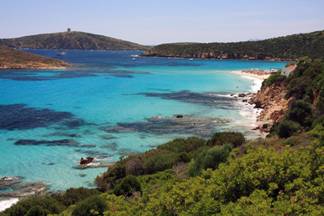
In a counterpoint to this underground world a wonderful coastline overlooking the Sea of ??Sardinia and that includes the island of San Pietro and the island of Sant'Antioco, the latter linked to the island by a strip of land bordering the pond of St. Catherine.
A harsh environment in some ways, very delicate in other aspects, with beautiful protected areas like the Sulcis Park, Mount Linas and Mount Caravius.
The Iglesiente remains one of the least affected by tourism, which has well preserved its natural beauty, offering itself to the visitor and the traveler as a piece of Sardinia authentic and worth discovering.
 within the structure of Monte Granaticovarious findings Neolithic, Nuraghic and Phoenician testimonies related to the foundation of sulci, the first Phoenician settlement in Sardinia ...
 southwest of Sardiniaunited by an artificial isthmus of about 3 km., with an area of about 109 sq km., it is part of the Archipelago Sulcis ...
 in the underground necropolis Punicthe visit is divided into two distinct areas, a covered part that "on magasinu" and a large courtyard, typical of Sulcis ...
 along a well markedin the territory of S. Antioco the nuragje are about thirty
 born in the early '900stands at the grave crisis in the mining sector and after the second war the city had to look for a new economic order, which would allow her to recover ...
 of Phoenician originwith the conquest of the island by the Pisani in the Middle Ages, the city developed and then live instead a critical stage when it was conquered in the '300 by the Aragonese ...
-
Search
-
Categories
- APP FAITA Sardegna
- HOLIDAY PACKAGES
- CAMPING VILLAGE Sardinia
- Where to eat
- TRANSPORT Sardinia
- BEACHES in Sardinia
- Tours in Sardinia
- KITCHEN traditional Sardinian
- WINES Sardinia
- SPIRITS of Sardinia
- EVENTS in Sardinia
- CORTES Apertas in Sardinia
- SPORT in Sardinia
- MAP Sardinia
- PHOTOS Sardinia
- VIDEO Sardinia
- Useful Numbers Sardinia
- DOGGIE BEACH in Sardinia
- Contact information
- archivio
-
Topics
- Camping e Village Sardinia
- Tourism in Sardinia
- resorts in Sardinia
- Sardinian beaches routes
- Specialties at the table
- South Coast Cagliari
- Costa Rei itinerari
- Ogliastra itinerari
- Nuoro e provincia itinerari
- Gallura itinerari
- Sassari e provincia itinerari
- Oristano e provincia itinerari
- Autunno in Barbagia 2013
- Aerei per la Sardegna
- Traghetti per la Sardegna
- Storia di Sardegna
- Feste e sagre della Sardegna
- Camping Village e Spiagge dog friendly
- Spiagge accessibili con l'amico cane
